Header Photograph shows the upper Hatea River at Mair Park.

THIS WEBSITE HAS BEEN PRODUCED BY NORTHLAND BOOKS [email protected] (C) Copyright Dennis K. Scoles 2012.If you have found this website helpful, you may wish to make a small donation towards the growth of this and other Northland Books sites - www.WhangareiFlora.weebly.com - www.HateaRiverWalk.weebly.com - www.CoronationReserve.weebly.com. Reciepts will be issued by Email on request. www.Kiwibank.co.nz. Northland Books account #38-9002-0814818-00. Thanks.
THE HATEA RIVER WALK
INCOPORATING THE PARIHAKA RESERVE, A.H.REED MEMORIAL KAURI PARK AND WHANGAREI FALLS SCENIC RESERVE.
North of Auckland on the east coast of the North Island of New Zealand, situated on a picturesque harbour, is the City Of Whangarei - Whangarei-terenga-paraoa as it was known to the Tangata Whenua of Aotearoa New Zealand in pre-European times. Whangarei is one of the most beautiful cities in New Zealand, surrounded by Native bush reserves and host to magnificent native and exotic trees, planted by early settlers, a practice that has continued down the years to make Whangarei an emerald jewel, a city of trees, but more importantly a city of wonderful bush walks through native bush reserves many of which can rival any elswhere in this land of Aotearoa 'The Land Of The Long Whair Cloud'.
THE MAGNIFICENT BUSH WALKS OF WHANGAREI.
HATEA RIVER WALK - The walk is a long one, but can be broken up into parts which are described below. It begins in the Town Basin at the carpark besise the Aquatic Centre, from where a short boadwalk leads visitors through the mangroves on the edge of the Hatea River. The walk continues to the left up Ewing Road, then turns right behind the last house in the street. The path then leads between houses, over a
small stream and up a rise onto Vale Road. A left turn takes you to the end of the road where a metal path signals the start of the Hatea River Walk through the bush.
SCROGGIN - also scrogen: occasionally abreviated to scrog. Origin
uncertain, but it is a mixture of dried fruits (raisins, dates, apricits) nuts,
chocolate etc. eaten by trampers as a high energy snack - e.g. 1940 Tararua
Tramper, March 7th - " We had our breakfast of scroggin. See also 'Don't Forget
Your scroggin' a handbook for New Zealand Trampers by Sarah Bennett & Lee
Slater, published by Craig Potton, 2007.
THE MANGROVE BOARDWALK
Before setting out on your Hatea River Walk, take time to walk through the Mangroves along the Hatea River mudflats. Access is by the rear of the car park at the Aquatic Centre. Track markers, with the sign of an eel (tuna) guides walkers along the track between Eliott Reserve and Whangarei Falls Scenic Reserve.
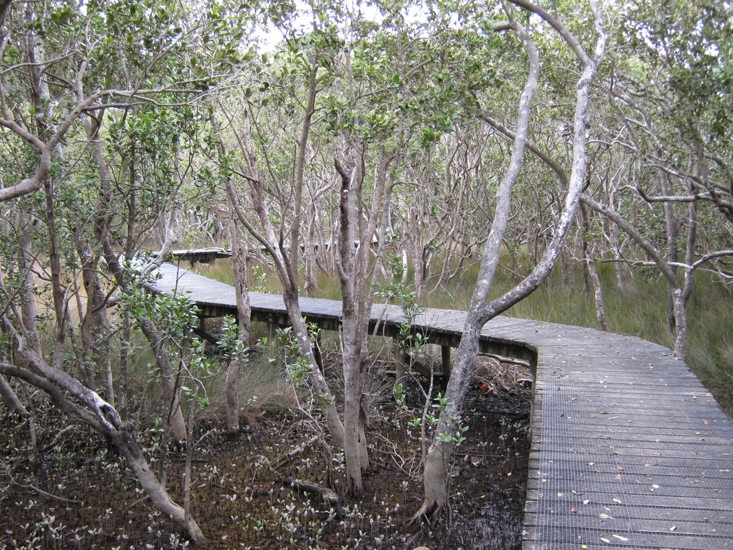
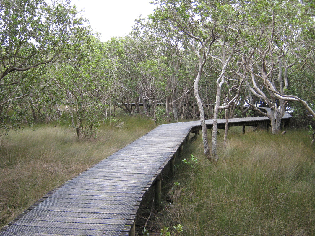
The boardwalk winds through the Mangroves
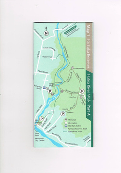
WHANGAREI DISTRICT COUNCIL MAP OF BUSH WALKS : AVAILABLE FROM FORUM NORTH, WHANGAREI, NEW ZEALAND. Contact - Ph (09) 430 4200.
HATEA RIVER WALK - This walk can be started at 3 point.
A : From the inner-city Ewing Road entrance. The distance to
Whareora Road is 2.9 kilometers, approx. walking time 64 minutes. To Mair Park
the distance is 1.3 kilometres, a 29 minute walk.
B : From Mair
Park to the inner city the distance is 1.3 kilometres, a 29 minute walk.
C : From Mair Park to Whareora Road the distance is 1.6
kilometres, a 35 minute walk.
From Whareora Road it is a further
1k. to the A.H. Reed Memorial Kauri Park, a 12 minute walk (see A.H. Reed
Memorial Park).
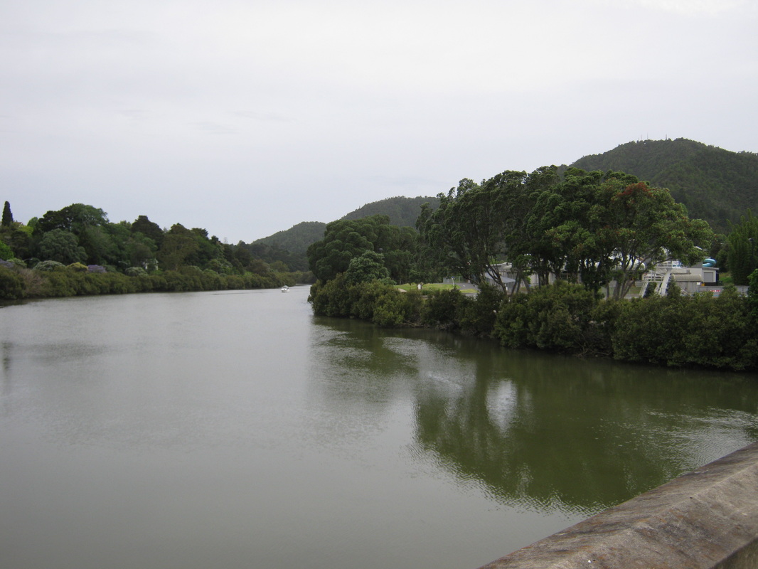
Looking up the Hatea River from the city. The Hatea River Walk follows the river bank all the way to the Whangarei Falls at Tikipunga.
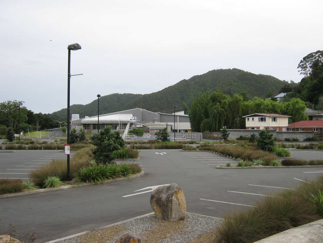
The Whangarei Aquaric Centre. Ample car parking to begin your adventure.
PARIHAKA RESERVE
THE MOUNT PARIHAKA TRACKS.
There are three tracks on the western side of the mountain, the Drummond track, the Ponga track and the Hokianga/Dobbie track, all with access from Mair Park, and via the Hatea River Walk on the western side of Mount Parihaka and the Ross Track up the other side of the mountain from Dundas Road. The first two tracks can be accessed over the footbridge in Mair Park. Of these the Drummond Track is the steepest, about a 40 minute walk to the summit lookout and war memorial. However, the Ross track on the other side of the Reserve is also very steep. The Ponga track is wild, unmetalled, and difficult in parts.
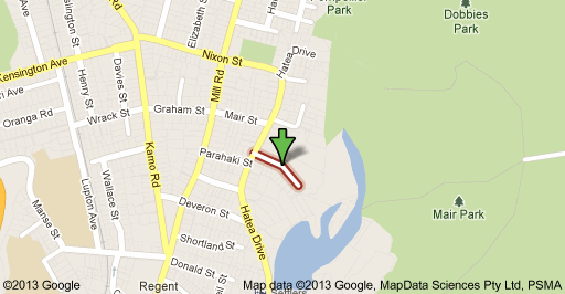
The Mair Park entrance is to the right of the footbridge. The Hokianga/Dobbie Track, to the left, is the longer of the two, but not as steep and so it is your choice as to which one to go up and which to come down. At the end of the Dobbie track is the old Maori Pa site. Mair Park is 9 hectares of the west bank of the Hatea River. It can be accessed via Deveron Reserve at the end of Banff Street, and Pompallier Park at the end of Wairere Avenue. However, the main access is via Rurumoki Street, off Hatea Drive.
The Mair Park foorbridge is the main access point for crossing the Hatea River to the walking tracks. Robert Mair was a local native plant enthusiast whose family settled in Whangarei in the 1840s. He presented Mair Park to the people of Whangarei in 1914 for the purposes of a public park or domain (see photographic section Parihaka Reserves page).
TO THE SUMMIT OF MOUNT PARIHAKA -
As mentioned there are three walks from the Mair Park side of Mount Parihaka. The Drummond track and the Hokianga/Dobbie track. The Hokianga/Dobbie track intersection is the beginning of the Ponga Track, an unsealed natural, rather wild track.
A : The Drummond Track - accessed from the footbridge across the Hatea River from Mair Park. Turn right and the entrance is a few meters on your left. A steep walk of 1.4 kilometres or approx. 40 minutes. Drummond park is 16 hectares and is located between Ross Park and Dobbie Park. It contains the Parihaka Memorial. Two additional parcels of land were added to the park in 183 to facilitate access from Vale Road to the reseves along the Hatea River, and to the Drummond and Ross Parks.
B : The Hokianga/Dobbie track : Turn left off the footbridge across the Hatea River
from Mair Park. The Hokianga track links up with the Dobbie track and is a
longer walk, but a more gentle climb. 1.9 kilometers in length about a 50 minute walk. Dobbie Park is 55 hectares and is immediately to the north and northwest of the Parihaka Memorial, which runs down to the Hatea River. The land was vested to council by deed in 1910, by Mr Herbert B. Dobbie, to be used as a public park and recreation ground.
C: The Ponga Track. The ponga track is off the end of the Hokianga Track. It is in a natural state and runs through wild bush that covers the track and in parts appears to be petering out, only to widen again, or pass through areas of clay and root where one must watch their footing. At one part it passes around the edge of a steep drop down to the bush below, or passes over small trickle streams. A wonderfully exciting track to walk. It eventually links with the Hatea River Walk down by the river, after winding along the bush but steadilly downwards. The flora consists mainly Tanekaha, Miro, Kauri.Nikau and Silver Tree Ferns. There is a variety of small ground cover.
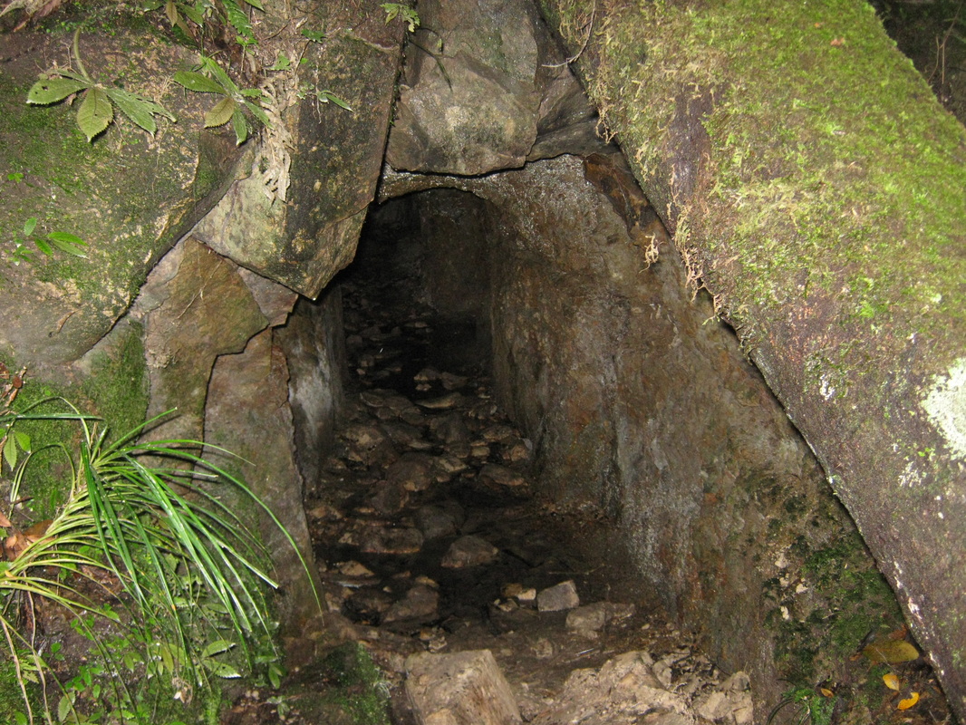
D: The Ross Track (see bottom right of map) leads to an otherwise isolated waterfall and the old goldmine, an early settlers unsuccessful venture. The entrance to the Ross Track is at the end of Dundas Road, the track follows an attractive stream up
through the bush. There is a staircase up past a small but attractive waterfall, and on the right, just before the staircase there is and area of bush in which you can see glow worms at night and the
entrance to the old gold mine, which dates back to
1909. Economic quantities of gold were never found. The track is 1.5 kilometers long with a walking time of about 40 minutes.
THE A.H. REED MEMORIAL KAURI PARK.
WHANGAREI DISTRICT COUNCIL MAP OF THE A.H. REED MEMORIAL KAURI PARK
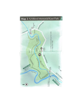
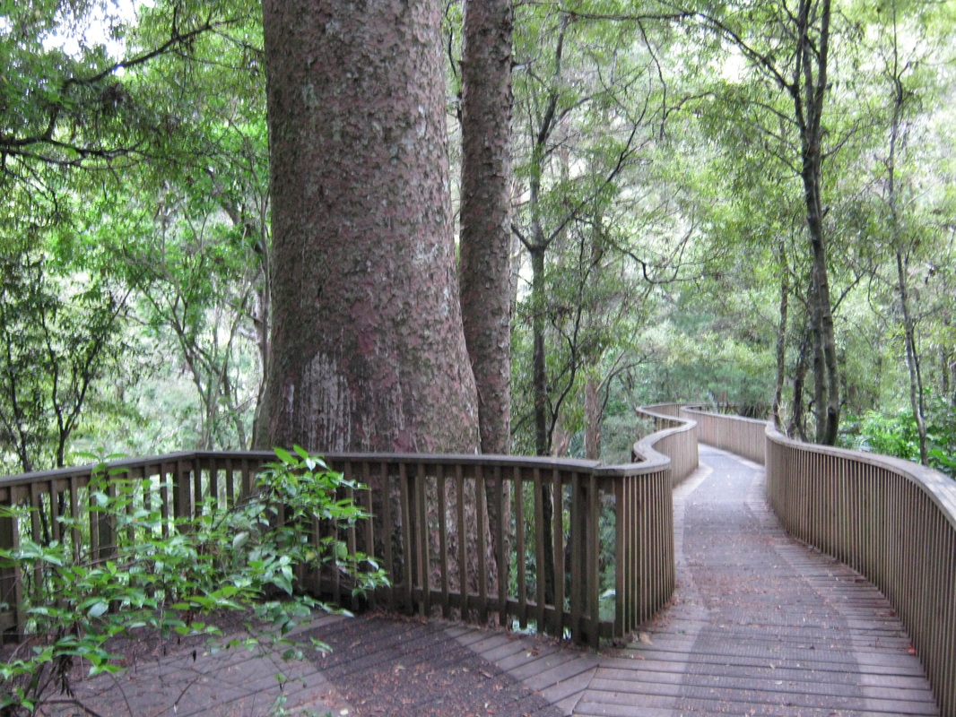
The Entance to the A.H. Reed Memorial Kauri Park is off Whareora Road. There are three entrances to the park, Lower, Middle and Upper (see map). the middle car park provides wheelchair access to the Canopy Walkway, a walkway constructed above the bush, providing visitors with a bird's eye view of the forest and Wai-Koromiko Sream below. The Canopy Walk and Alexander Walkway are designed for access for wheelchairs, the Alexander Walkway can also be accessed from the lower car park. A large sign board will great visitors setting out the features of the park and the various tracks, one of which will lead visitors through the stand of Kauri trees, to the lesser known waterfall which is 28.8 metres high and was originally considered more scenic than the Whangarei Falls, further up
the valley at Tikipunga. However, visitors can walk through to the Tikipunga falls, through farmland and over fences and gates. This is a continuation of the Hatea River Walkway.
The A.H. Reed Memorial Kauri Park Walkways begin at the bottom car park. The Elizabeth Track leads around the back of the park then cuts through to the middle car park, but the McKinnon track lead around the rear of the park off the Elizabeth track to the upper car park at the Clapham Road end of the park. The Alexander Track leads around the front of the park to the Canopy Walk and links with the McKinnon track to the waterfall. The park is named after A.H. Reed publisher and noted walker who began his working life at the age of 14 as a gumdigger with his father, after the family came out from England. They dug gum below Mt Parihaka, and the old homestead was on Clapham Road, at the opposite side of the road from the upper carpark. One cannot put a time or distance on these walks, it is entirely up to the visitor, but like me, you might enjoy a picnic snack on a bench in the Kauri Grove. However, officially, the Elizabeth track is 490 metres from the lower carpark to the Kauri Grove and Canopy Walk. the Elizabeth Track from the lower carpark through the Kauri Grove and canopy walk, back via the Alexander Track is 890 metres. the tracks provide easy walking with a steeper climb to the waterfall.
Visitors should be aware that this kauri bush is a remnant of the magnificent kauri forest that once covered Northland, and contained huge kauri trees thousands of years old, like the few remaining further north in forests Like Waipoua, great trees like Tane Mahuta (see photographic section A.H. Reed Memorial Kauri Park page).
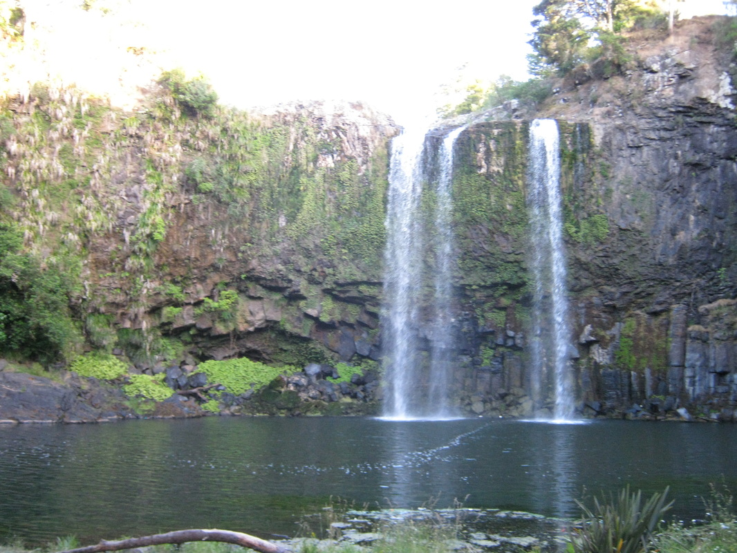
THE WHANGAREI FALLS SCENIC RESERVE.
WHANGAREI DISTRICT COUNCIL MAP OF THE WHANGAREI FALLS SCENIC RESERVE .
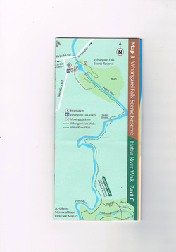
The Hatea River Walk to the Whangarei Falls, follows the Hatea River from the A.H. Reed Memorial Kauri Park, off the back of the Elizabeth Track, the entrance to which is pictured above. It is 1.84 kilometres long, with a walking time of
approx. 22 minutes. It is an easy hike through farmed sheep pastureland, where mature trees and the remnants of the Clapham's tennis courts are evidence of the early settlers of this area of Whangarei. There is a swing bridge to take walkers across the river, and passes a number of safe swimming holes which are used by the locals in the summer months. A bend in the Hatea River signals the track's re-entry to native bush, where a rich variety of mature native trees and plants grow along both banks of the river. You arrive rather suddenly at a clearing which brings the walker to the foot of the Whangarei Falls, from where a zig-zag track takes the visitor to the Whangarei falls reserve.
This area is known to Maori as Otuihau, and was one of the traditional eeling spots. The reserve itself is spacious, park-like and provides shade trees, park benches and a lookout to photograph the falls, which are at their best after rain in the northern area (see photographic section Whangarei Falls Scenic Reserve page).